 Galactic Constellations
The images on this website are slices from a massive 3D map of galaxies, created by the Dark Energy Spectroscopic Instrument (DESI). DESI is measuring the distances to 63 million galaxies over 8 years. The data used here are from a portion of DESI's first public data release (DR1), containing 14 million extragalactic spectra.
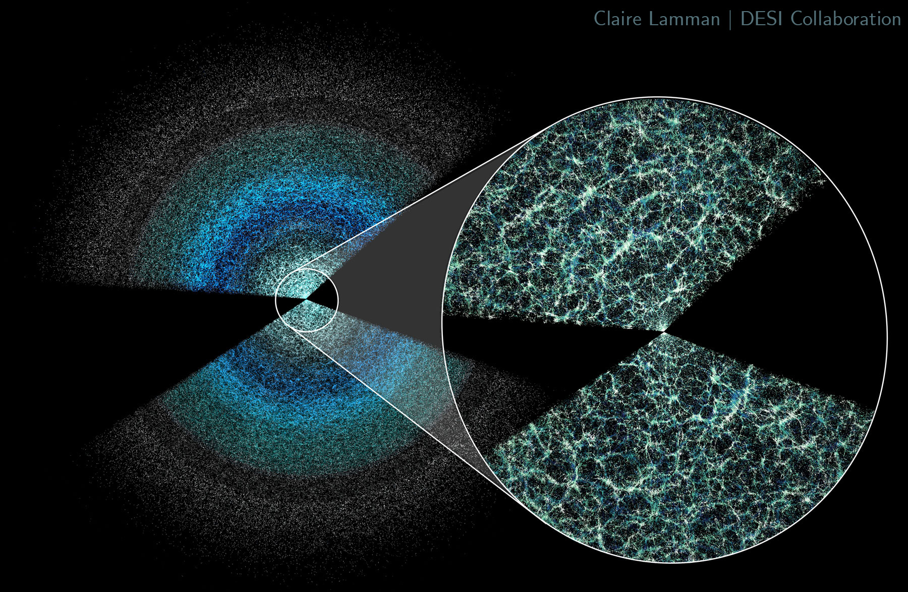
From the full DR1 catalog, these images of the cosmic web come from a band of the sky where the survey is very complete. This sky band results in a 3D wedge of the cosmic web, as shown in this video. The galaxies you see here are also limited to the closest galaxies that DESI observes, mostly within redshift z = 0.8 or about 3.5 billion light years. This is the most complete part of DESI's survey, where you can best see galaxies tracing the giant underlying web of dark matter.
The full survey extends much farther. A slice of DESI's five-year survey (what will eventually be DR3) is shown here. The furthest galaxies in the image are 11 billion light years away; the light we observed left those galaxies when the universe was just 1/5 its current age and 1/3 its current size! Stay tuned for updates to this website when more DESI data becomes public.
Why are there gaps in the map?
An image with a large dark area is probably close to the edge of the survey. DESI only measures galaxies above the Milky Way (corresponding to the top of wedge of the butterfly shown above) and below it. The gap between the wedges is dark because it contains galaxies obscured by our own galaxy. Also, sometimes there is a gap in the survey. An unobserved patch of sky will look like a long dark stripe in these images, which stretch away from Earth.
Why are there streaks of galaxies?
This is an artifact of how we determine the distances to galaxies. DESI measures how fast galaxies move relative to Earth. Since the universe is expanding, this is a good measure of their distance. The further away a galaxy is, the more space there is between us to expand, and the faster the galaxy moves away from us. However, galaxies also move around each other in clusters. This addition of random velocities will smear their positions in the map. It looks like "Fingers of God" stretching towards Earth. If you see them, they are pointing the way home!
How are these images created? (for nerds)
The sky position and redshift of galaxies are converted to comoving space: a way of measuring space that is constant as it expands. These 3D points were split into slices corresponding to 2 deg in sky declination and then trimmed to squares. The sizes listed correspond to one edge of the square image. In each image, right ascension approximately spans across one side of the image and redshift another. Points are shaded based on declination to distinguish between foreground and background structure. For more details about this site and galactic constellations, see this paper: Galactic Constellations in DESI DR1 and the Scales of Cosmological Homogeneity